Istanbul is one of the most exciting cities in the world, but moving through it can feel overwhelming without a simple transport companion. The city stretches across Europe and Asia, combines metro, tram, rail, ferries, buses, airport transfers and historic walking areas, and every trip can involve more than one transport decision. The Istanbul Subway Map app was created to make that experience cleaner, faster and easier to understand.
Developed by HEDONISM Design, this iOS travel and navigation app brings together practical tools for people who want to explore Istanbul with more confidence. Instead of switching between many pages, maps, notes and search results, users can open one mobile app and access the core information they need: metro maps, station-to-station route planning, airport boards, fare basics, useful city contacts, travel guides and emergency help.
The goal is simple: help people move through Istanbul with less stress.
What Is the Istanbul Subway Map App?
The Istanbul Subway Map app is a practical iOS navigation app designed for visitors, tourists and everyday city trips in Istanbul. It focuses on the transport questions that matter most when someone is already in the city or planning a route before leaving the hotel.
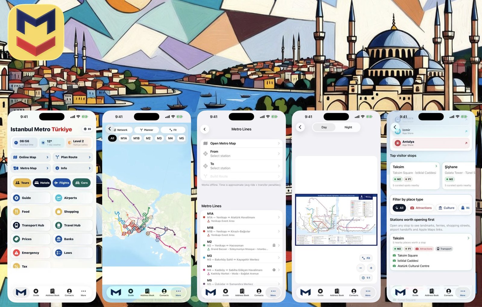
Users can view an online Istanbul metro and rail map, browse metro lines and station information, plan routes between stations and use a clean interface built around large buttons and quick access cards. The app also includes an offline route planner with approximate travel and transfer times, making it useful when mobile internet is unstable or when a traveler wants to check a route quickly.
This is not only a map viewer. It is a compact Istanbul travel toolkit designed around real movement: arriving at the airport, reaching a hotel, finding a landmark, saving an address, checking transport basics and keeping important contacts nearby.
Why Istanbul Needs a Simple Metro Navigation App
Istanbul is beautiful, energetic and complex. A traveler may land at Istanbul Airport, continue by metro or shuttle, transfer toward the city center, visit Taksim, explore the Grand Bazaar, cross to Kadıköy, use ferries, return through Sabiha Gökçen Airport or combine several transport modes in one day.
That is why a basic map is often not enough. Travelers need context.
The Istanbul Subway Map app is designed for this exact situation. It helps users understand how metro movement connects with airports, visitor districts, shopping streets, ferry areas and key city handoffs. For someone visiting Istanbul for the first time, this can save time and reduce confusion. For someone already familiar with the city, it becomes a fast reference tool for checking maps, routes and useful places.
Key Features of the Istanbul Subway Map App
Online Istanbul Metro and Rail Map
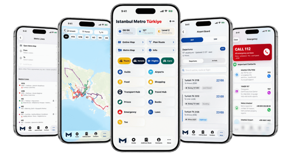
The core of the app is a clean Istanbul metro and rail map. Users can open the network, zoom in, zoom out and understand how the main lines connect. This is useful for checking routes before starting a trip, confirming transfers or simply getting a better sense of the city’s transport structure.
A good metro app should not feel heavy. It should open quickly, show the map clearly and make the next step obvious. That is why the Istanbul Subway Map app uses a simple layout with quick cards and accessible navigation sections.
Metro Lines and Station Details
The app is built for practical movement, not just visual browsing. Users can explore metro lines and station-related information, helping them understand where they are going and how different parts of the network connect.
For tourists, this is especially helpful when planning routes to popular areas such as Taksim, Şişhane, the Grand Bazaar, Kadıköy, ferry connections and shopping districts. Instead of searching every destination separately, users can keep a transport-focused guide inside the same app.
Station-to-Station Route Planning
One of the most important features is route planning between stations. A traveler can check how to move from one point to another, review route results and understand the trip before entering the station.
This is useful for airport transfers, hotel-to-landmark routes, shopping trips, ferry connections and everyday movement across the city. Route planning is especially valuable in Istanbul because many trips require transfers, and a clear route view can make the journey much easier to follow.
Offline Route Planner
Mobile internet is not always reliable while traveling. Some users may not have roaming, some may be underground, and others may simply want to avoid using data. The offline route planner gives users a practical backup for checking approximate ride and transfer times without depending on a constant internet connection.
For a travel app, this is a major advantage. It makes the app useful not only during perfect conditions but also during real travel moments when connection quality changes.
Day and Night Network Maps
Istanbul is not only a daytime city. People move around for evening dinners, late arrivals, entertainment, airport transfers and early departures. The app includes access to day and night network maps with zoom and fit controls, helping users understand transport options across different travel scenarios.
This makes the app more flexible for users who do not travel only during standard daytime hours.
Airport Boards for IST and SAW
Istanbul has two major airport gateways: Istanbul Airport and Sabiha Gökçen Airport. For visitors, airport movement is one of the most stressful parts of the trip. The Istanbul Subway Map app includes airport board sections for IST and SAW, allowing users to check departures and arrivals in a travel-focused interface.
This feature fits naturally with the app’s purpose. A user may plan a metro route, check an airport handoff, save a hotel address and keep travel contacts in one place.
Fare and Istanbulkart Basics
Transport prices, ticket rules and local cards can confuse first-time visitors. The app includes fare and Istanbulkart basics so users can quickly understand the general payment context before a trip.
This section is not meant to replace official transport sources, because fares and rules can change. Instead, it gives travelers a simple starting point and reminds them to confirm critical information with official providers when needed.
City Guide by Metro
A useful metro app should help users understand not only lines and stations, but also what those stations connect to. The Istanbul Subway Map app includes visitor-focused guidance for important city areas, landmarks, shopping streets and transport handoffs.
This makes the app more than a technical transport tool. It becomes a small Istanbul city guide built around movement. Users can discover where to go, how metro stations relate to popular areas and what transport connections may be useful during the trip.
Address Book for Saved Places
When traveling, users often need to save places quickly: hotel address, apartment location, airport meeting point, restaurant, tour office, shopping street or emergency contact location. The address book feature helps users keep important places inside the app instead of losing them in screenshots or browser tabs.
This is especially useful for visitors who do not know Istanbul well and want to avoid searching for the same address again and again.
Useful Contacts and Emergency Help
The app includes practical contact sections for city help, transport support, airports and emergency situations. This is an important part of the app’s travel-first design.
When people are in a new city, the most valuable app is not always the one with the most features. It is the one that helps quickly in the right moment. Emergency numbers and practical calling tips make the Istanbul Subway Map app more useful for real-life travel situations.
Who Is the Istanbul Subway Map App For?
The app is designed for several groups of users.
First, it is useful for first-time visitors to Istanbul who need a simple way to understand the metro system, airport routes and key tourist areas.
Second, it works well for tourists who want to plan routes by metro and avoid wasting time switching between different websites and map screenshots.
Third, it helps travelers arriving through Istanbul Airport or Sabiha Gökçen Airport who need airport boards, transfer context and route planning in one place.
Fourth, it is practical for people who want to check fare basics, save useful addresses and keep emergency contacts close.
Finally, it can also help everyday city users who want a clean metro reference app with a focused interface.
Designed by HEDONISM: Built for Cities, Designed for People
HEDONISM Design creates mobile applications that make everyday tasks smoother, cleaner and more enjoyable. The Istanbul Subway Map app fits into the studio’s wider collection of metro maps and travel-focused iOS projects.
The design approach is practical: large buttons, quick cards, clean navigation, useful guides and a focused experience. The app does not try to overwhelm the user. It tries to answer the most important travel questions quickly.
Where is the metro map?
How can I plan a route?
What airport information do I need?
Where did I save my hotel address?
Which contacts may be useful?
What should I know before taking public transport in Istanbul?
A good travel app should reduce friction. That is the idea behind this project.
Istanbul Subway Map App vs. a Standard Map App
Standard map apps are powerful, but they are not always optimized for a specific travel situation. A general map may show streets, businesses, traffic, reviews and many unrelated details. That can be helpful, but it can also create noise.
The Istanbul Subway Map app is more focused. It is built around metro navigation, public transport context and city travel essentials. This makes it easier for users who want a direct answer instead of a large general-purpose map experience.
The app is especially useful when someone wants to stay inside a transport-focused workflow: open metro map, check route, review airport board, find visitor stop, save address, open useful contact or access emergency information.
Independent Travel App Notice
The Istanbul Subway Map app is an independent travel application. It is not affiliated with, endorsed by or officially connected to Metro Istanbul, Istanbul Metropolitan Municipality, Istanbul Airport, Sabiha Gökçen Airport or any transport authority.
For critical travel details, fare changes, airport information, legal guidance and emergency instructions, users should always confirm information with official sources. The app is designed as a practical companion, not as an official authority.
Why This App Matters for Istanbul Travel
Travel apps are most valuable when they solve real moments of uncertainty. Istanbul creates many of those moments because the city is large, layered and constantly moving. A visitor may need to understand the metro network, find a transfer, reach an airport, check a station near a landmark, save a hotel address and keep emergency numbers nearby.
The Istanbul Subway Map app brings those needs into one clean mobile experience.
It helps users travel with more confidence, whether they are landing in Istanbul for the first time, crossing the city for sightseeing, planning a shopping route, connecting to a ferry or simply trying to avoid confusion before entering the metro.
Download the Istanbul Subway Map App
The Istanbul Subway Map app is available on the App Store. It is designed for iPhone and iPad users who want a practical Istanbul metro map, route planner and travel toolkit in one place.
Download on the App Store: Istanbul Subway Map
FAQ: Istanbul Subway Map App
Is the Istanbul Subway Map app free?
Yes, the app is listed as a free app on the App Store. It is designed as a practical travel and navigation tool for Istanbul metro users, visitors and tourists.
Does the app work on iPhone and iPad?
Yes. The app is designed for iPhone and iPad, making it useful both on a phone during travel and on a larger screen while planning a route in advance.
Can I use the app for airport travel in Istanbul?
Yes. The app includes airport board sections for IST and SAW, as well as travel tools that can help users plan airport-related movement and transport handoffs.
Does the app include an offline route planner?
Yes. The app includes an offline route planner with approximate ride and transfer times, which can be helpful when mobile internet is limited or unavailable.
Is this an official Metro Istanbul app?
No. The Istanbul Subway Map app is an independent travel app. Users should confirm critical transport, fare, airport, legal and emergency information with official sources.
Who should download the Istanbul Subway Map app?
The app is useful for tourists, first-time visitors, airport travelers, city explorers and anyone who wants a simple Istanbul metro map with route planning, travel tools and practical city information.
Conclusion
The Istanbul Subway Map app is a focused iOS travel companion built for one of the world’s most dynamic cities. It combines metro maps, station-to-station route planning, offline route support, airport boards, fare basics, city guides, saved addresses, useful contacts and emergency help in one clean interface.
For travelers who want to explore Istanbul with more confidence, this app offers a simple and practical way to understand the city’s metro system and move through the city with less stress.
Built by HEDONISM Design, the app reflects a clear product idea: good mobile design should make travel easier, faster and more enjoyable.
 Previous Post
 Next Post